Water Quality Technical Primer
Texas Surface Water Quality Standards
The Texas Surface Water Quality Standards (TSWQS) establish goals to maintain the quality of streams, rivers, lakes, and bays throughout the state. Appendix A and Appendix D of the TSWQS establish the geographic boundaries and the appropriate standards for each body of water. Standards ensure public health and enjoyment, protect aquatic life, and remain consistent with the sustainable economic development of the state. The Texas Commission on Environmental Quality (TCEQ) develops the TSWQS under the authorization of the U.S. Clean Water Act (CWA) and Texas Water Code. The standards are approved by the U.S. Environmental Protection Agency (EPA).
Drainage Areas - Basins, Watersheds, and Sub-Watersheds
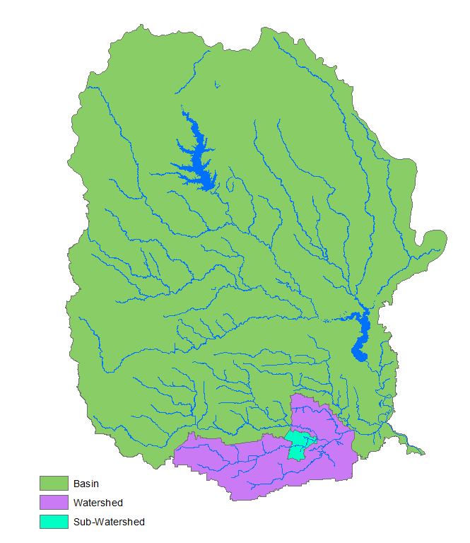
A watershed is a defined geographic area that waterways flow through on the way to a common body of water. Basins are larger geographic areas generally containing one or more watersheds. A river basin is a collection of watersheds drained by a major river and tributaries. A coastal basin is a collection of watersheds adjacent to the coastline that water flows through on its way to the ocean. Typically, coastal basins are between two major river basins. Watersheds can be broken down into smaller drainage areas called subwatersheds.

Water bodies, Segments, and Assessment Units
Water Bodies and Segments
The term water body is used to refer to any mass of water. A water body can be contained in a lake or a bay, or flow, such as a river, creek, or bayou. The TCEQ divides water bodies in the state into distinct segments that generally represent natural watersheds, and are intended to have similar chemical, physical, and hydrological characteristics. Each segment is assigned a four-digit code. The first two digits identify the river basin, and the last two digits identify the segment.
For example, Buffalo Bayou, a water body within the San Jacinto River Basin (Basin 10), has been divided into three segments: 1014–Buffalo Bayou Above Tidal, 1013–Buffalo Bayou Tidal, and 1007–Houston Ship Channel (HSC)/Buffalo Bayou Tidal. The different characteristics of each section warrant division into three separate segments.

Classified Segments
The TCEQ has designated segments 1014, 1013, and 1007 as classified segments, meaning these segments are described in the TSWQS. Typically, classified segments are major waterways.
Site-specific numerical
criteria are developed to evaluate the uses and
water quality of classified segments. The parameters
evaluated include bacteria and dissolved oxygen.
Aquatic life use (ALU) consists of
five categories: minimal, limited, intermediate,
high, and exceptional. In Texas, water bodies not
specifically listed in Appendix A or D of the TSWQS
are presumed to have a high aquatic life use and
corresponding dissolved oxygen criteria. Higher uses
are protected where they are attainable. Water
bodies included in Appendix A or D have adjusted
uses based on dissolved oxygen data and
nekton and macrobenthic
invertebrate community evaluations.
Segments 1007, 1107, and 1108 are all included in
Appendix A of the TSWQS, indicating site-specific
uses that deviate from the criteria for high aquatic
life use.
It is critical to protect human health in water bodies used for recreation. The TSWQS protects human health by setting numeric criteria for bacteria in a waterbody relative to the types of recreation occurring on that waterbody. Indicator bacteria levels are measured to determine risk. In freshwater, the indicator is Eschericia coli (E. coli) bacteria. Enterococci bacteria are measured in tidal water bodies
If activities are likely to result in ingestion of water (swimming, diving, tubing, surfing, wading by children), bacteria concentrations need to be lower. Categories of recreational use are based on the type and frequency of recreation. Primary contact recreation refers to activities involving a high likelihood of ingesting water. Secondary contact recreation refers to activities with limited body contact, such as boating, fishing, and canoeing. If such activities occur frequently, the designation is secondary contact recreation A water body could be classified as supporting noncontact recreation if conditions are unsafe to engage in any activities in the water. Primary contact recreation is the presumed recreational use in Texas waterbodies unless there is evidence to show that the waterbody is not used for primary contact recreation. A Recreational Use Attainability Analysis (RUAA), discussed later in this primer, is necessary to change the presumed use of a waterbody.
Unclassified Segments
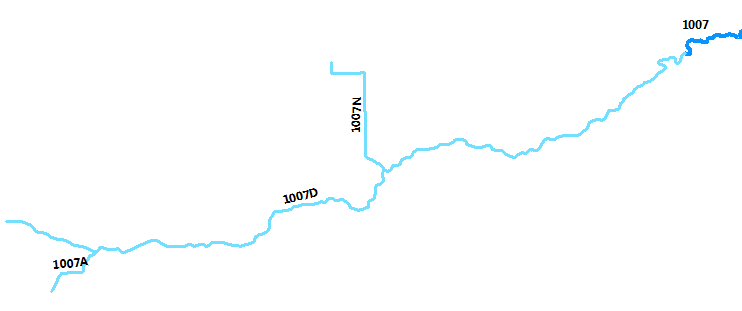
Unclassified segments are often tributaries of classified segments. These segments are usually assessed based on the criteria of the classified segment into which they flow. Some unclassified segments have been assigned specific water quality standards in the TSWQS. Unclassified segments are assigned the same four-digit code as the classified segment and a letter specific to that waterway.
For example, Sims Bayou Above Tidal is an unclassified segment identified as 1007D. The first four digits represent classified segment 1007 (HSC/Buffalo Bayou Tidal) that Sims Bayou Above Tidal flows into, and a letter unique to Sims Bayou Above Tidal (D). Sims Bayou Above Tidal has two major tributaries, also unclassified (1007A and 1007N).

Assessment Units (AUs)
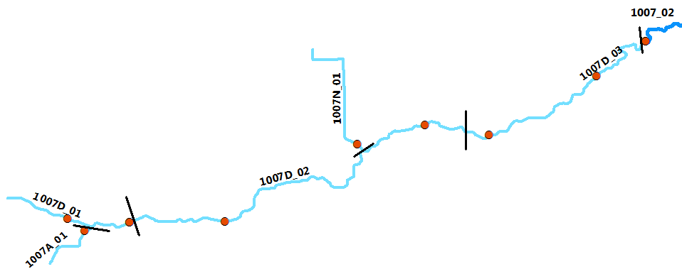
Each segment is subdivided into hydrologically-distinct assessment units (AUs). AUs are the smallest geographic areas of a water body that can support a designated or site-specific use. A segment may have one or multiple AUs, depending on water quality conditions or flow in different sections of the water body. Each AU has the same four- or five-character code as the segment followed by an _01. If the there are multiple AUs, the assessment units will generally be in sequential order (i.e. 1007D_01, 1007D_02).
For example, Sims Bayou Above Tidal has been divided into three AUs. The red dots in the graphic below represent monitoring stations. Monitoring stations have been placed on the downstream and upstream ends of each AU in 1007D. The smaller tributaries, 1007A and 1007N, have one monitoring station close to the confluence with the unclassified segment 1007D.

Water Quality Monitoring
The term water
quality is used to describe the chemical,
physical, and biological characteristics of water
for general or designated uses. Water quality
monitoring is the process of
sampling and analyzing water quality parameters over
time. The type of monitoring conducted by the Clean
Rivers Program (CRP) is routine,
meaning it is monitoring that is scheduled in
advance without intentionally trying to target any
certain environmental condition; samples are
collected regardless of the conditions encountered.
Routine monitoring generally consists of field
measurements (Dissolved Oxygen [DO], pH, specific
conductance, temperature), conventional chemical
parameters (nutrients, chloride, sulfate), bacterial
measurements (E. coli or enterococci), and flow
measurements (if applicable for that water body).
Please see the
Monitoring can include biased (targeted to a season, time, or condition) measurements, such as 24-hour DO. In this procedure, a data sonde (a water-quality monitoring device that calculates and records field parameters) is deployed to measure DO every 15 minutes for 24 hours. After the deployment period, the data is analyzed and the 24-hour average and absolute minimum are calculated. The DO average and absolute minimum are used to assign an ALU category to a water body. For example, exceptional aquatic life use has a 24-hour average of 6.0 mg/L and an absolute minimum of 4.0 mg/L.
Assessment of Water Quality Data
The provisions of sections 305(b) and 303(d) of the Clean Water Act require the TCEQ to provide the Texas Integrated Report for Clean Water Act Sections 305(b) and 303(d) (IR) to the EPA every two years. The report contains a list of water bodies evaluated, water bodies assessed by basin, impaired water bodies (303(d) List), water bodies of concern, water bodies either newly listed or removed from the 303(d) List, and other supporting information.
Each assessed water body is identified as:
-
Fully supporting: At least ten data points (20 for bacteria) are available for an assessment, and the water body meets TSWQS or supports designated uses
-
Of concern: There are two types of water body concern, CN and CS. CN means there is concern for near nonattainment of the TSWQS based on numeric criteria. CS means there is concern for water quality based on screening levels. Screening levels are derived from statistical distributions of statewide water quality monitoring data, and the 85th percentile for each applicable parameter is used as the screening criteria level.
-
Impaired: Data indicates that the water body does not meet standards. Impaired water bodies are placed on the 303(d) List.
Management Measures
for Impaired Water Bodies
If sufficient data is available to determine that a water body is impaired and does not meet standards, a management measure can be utilized to address the impairment.
-
Total Maximum Daily Load (TMDL) is a method used to determine the amount (i.e. load) of a pollutant an impaired waterbody can receive daily and still meet water quality standards and designated uses. After a load is calculated for the pollutant sources, an implementation plan (I-Plan) is drafted by the water body’s stakeholders outlining management measures to be used to return the target pollutant to the calculated load. An I-Plan’s management measures are usually voluntary actions but can, if recommended by stakeholders, include regulatory actions.
-
Use Attainability Analysis (UAA) determines if the natural characteristics of a water body cannot attain the currently designated uses and/or criteria. Natural characteristics include temperature, pH, DO, diversity of aquatic organisms, amount of streamflow, and physical conditions such as depth.
-
A Recreational Use Attainment Analysis (RUAA) is like a UAA but determines if contact recreation use is appropriate for a water body. A waterway may have physical characteristics or limited public access that would not warrant a contact recreation use designation.